
Make a donation
Gear up for your next adventure:
As an Amazon Associate, this site earns from qualifying purchases at no extra cost to you.
Big River topographic map
Click on the map to display elevation.
Make a donation
Gear up for your next adventure:
As an Amazon Associate, this site earns from qualifying purchases at no extra cost to you.
Big River
The Big River is a tributary of the Meramec River in east-central Missouri. The river rises in western Iron County near the summit of Johnson Mountain just north of Missouri Route 32 and approximately 3.5 miles southeast of the community of Enough. It flows through Washington, Saint Francois, and Jefferson counties. It forms part of the boundary between Jefferson and Saint Francois counties and also part of the boundary between Jefferson and Washington counties. It empties into the Meramec River opposite Eureka where the Meramec forms the border between Jefferson and Saint Louis counties. The river flows through Washington State Park, St. Francois State Park, and the Lead Belt mining district. The elevation of the river at its source is approximately 1,300 feet (400 m) above sea level and at its mouth about 400 feet (120 m). The length of the river is approximately 145 miles (233 km), while the airline distance between source and mouth is about 56 miles (90 km). Its watershed area is 955 square miles (2,470 km2).
Make a donation
Gear up for your next adventure:
As an Amazon Associate, this site earns from qualifying purchases at no extra cost to you.
About this map
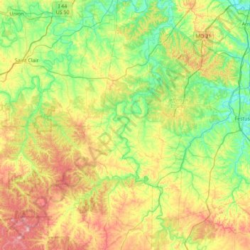
Name: Big River topographic map, elevation, terrain.
Average elevation: 220 m
Minimum elevation: 116 m
Maximum elevation: 429 m
Make a donation
Gear up for your next adventure:
As an Amazon Associate, this site earns from qualifying purchases at no extra cost to you.