
Tigard topographic map
Interactive map
Click on the map to display elevation.
About this map
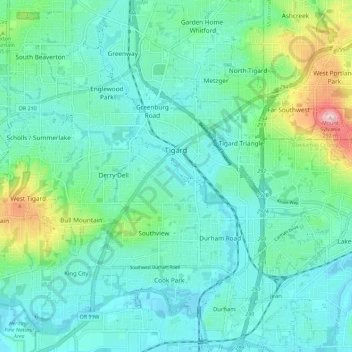
Name: Tigard topographic map, elevation, terrain.
Location: Tigard, Washington County, Oregon, États-Unis d'Amérique (45.39324 -122.85692 45.45643 -122.74342)
Average elevation: 83 m
Minimum elevation: 31 m
Maximum elevation: 288 m
Other topographic maps
Click on a map to view its topography, its elevation and its terrain.
Hillsboro
États-Unis d'Amérique > Oregon > Washington County > Hillsboro
Hillsboro, Washington County, Oregon, États-Unis d'Amérique
Average elevation: 53 m
Vose
États-Unis d'Amérique > Oregon > Washington County > Beaverton
Vose, Beaverton, Washington County, Oregon, États-Unis d'Amérique
Average elevation: 70 m