
Make a donation
Gear up for your next adventure:
As an Amazon Associate, this site earns from qualifying purchases at no extra cost to you.
Serra de Madureira topographic map
Click on the map to display elevation.
Make a donation
Gear up for your next adventure:
As an Amazon Associate, this site earns from qualifying purchases at no extra cost to you.
About this map
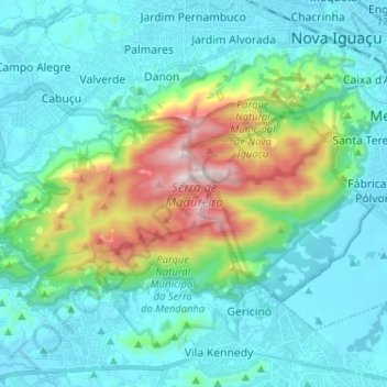
Name: Serra de Madureira topographic map, elevation, terrain.
Average elevation: 198 m
Minimum elevation: 13 m
Maximum elevation: 939 m
Make a donation
Gear up for your next adventure:
As an Amazon Associate, this site earns from qualifying purchases at no extra cost to you.
Other topographic maps
Click on a map to view its topography, its elevation and its terrain.
Rio Botas
Brasil > Rio de Janeiro > Região Metropolitana do Rio de Janeiro > Nova Iguaçu
Average elevation: 79 m
Rio Queimados
Brasil > Rio de Janeiro > Região Metropolitana do Rio de Janeiro > Nova Iguaçu
Average elevation: 12 m
Nova Iguaçu
Brasil > Rio de Janeiro > Região Metropolitana do Rio de Janeiro > Nova Iguaçu
Average elevation: 86 m
Serra do Mendanha
Brasil > Rio de Janeiro > Região Metropolitana do Rio de Janeiro > Nova Iguaçu
Average elevation: 137 m
Make a donation
Gear up for your next adventure:
As an Amazon Associate, this site earns from qualifying purchases at no extra cost to you.