
Make a donation
Gear up for your next adventure:
As an Amazon Associate, this site earns from qualifying purchases at no extra cost to you.
Municipio San Julián topographic map
Click on the map to display elevation.
Make a donation
Gear up for your next adventure:
As an Amazon Associate, this site earns from qualifying purchases at no extra cost to you.
Municipio San Julián
San Julián es un municipio en la provincia Ñuflo de Chaves y se encuentra a 150 km al noroeste de la ciudad de Santa Cruz de la Sierra, la capital departamental. La topografía presenta llanuras y la temperatura media anual es de 24,3 °C. El río Grande o Guapay bordea el extremo occidental de San Julián Sur y Berlín, mientras que el río San Julián bordea el extremo oriental de Brecha Casarabe.
Make a donation
Gear up for your next adventure:
As an Amazon Associate, this site earns from qualifying purchases at no extra cost to you.
About this map
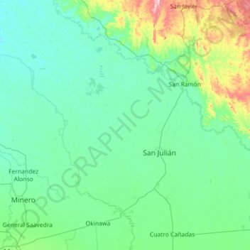
Name: Municipio San Julián topographic map, elevation, terrain.
Average elevation: 272 m
Minimum elevation: 203 m
Maximum elevation: 821 m
Make a donation
Gear up for your next adventure:
As an Amazon Associate, this site earns from qualifying purchases at no extra cost to you.
Other topographic maps
Click on a map to view its topography, its elevation and its terrain.
San Antonio de Lomerio
Bolivia > Santa Cruz > Provincia Ñuflo de Chávez > Municipio San Antonio de Lomerio
Average elevation: 369 m
Nucleo 15 Villa Pampa
Bolivia > Santa Cruz > Provincia Ñuflo de Chávez > Municipio San Julián
Average elevation: 237 m
Make a donation
Gear up for your next adventure:
As an Amazon Associate, this site earns from qualifying purchases at no extra cost to you.
Nucleo 31B Entre Rios
Bolivia > Santa Cruz > Provincia Ñuflo de Chávez > Municipio San Julián
Average elevation: 224 m