Geolocate

Kuhi topographic map

Click on the map to display elevation.

About this map

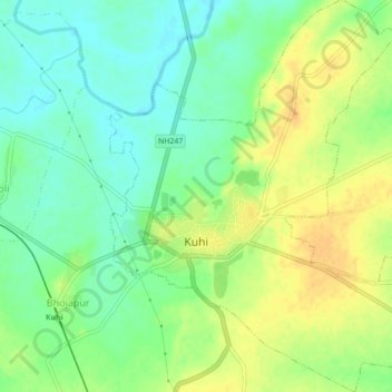
Name: Kuhi topographic map, elevation, terrain.

Location: Kuhi, Kuhi Taluka, Nagpur, Maharashtra, India (20.99818 79.35654 21.03936 79.39326)

Average elevation: 272 m

Minimum elevation: 257 m

Maximum elevation: 287 m

Gear up for your next adventure:

🥾Approach Shoes - Shoes designed for climbing approaches and rugged trails
🧢Hiking Hat - Sun-protective and breathable hats for long treks
🪑Ultralight Camping Stool - Compact seating for rest stops during long hikes
💧Hydration Bladder - Hands-free hydration solution for long treks
🥤Collapsible Travel Cup - Saves space and weight in your mess kit

As an Amazon Associate, this site earns from qualifying purchases at no extra cost to you.