
Make a donation
Gear up for your next adventure:
As an Amazon Associate, this site earns from qualifying purchases at no extra cost to you.
Amden topographic map
Click on the map to display elevation.
Make a donation
Gear up for your next adventure:
As an Amazon Associate, this site earns from qualifying purchases at no extra cost to you.
Amden
Die bekanntesten Berge auf dem Gebiet der Gemeinde Amden sind Leistchamm, Flügenspitz, Gulmen, Mattstock, Speer, Chapf und Durschlegi. Unterhalb des Dorfes Amden liegt zudem der Seerenbachfall, bestehend aus drei Wasserfällen mit einer Gesamthöhe von 585 m, der höchste Wasserfall der Schweiz. Gleich an dessen Fuss liegt die Rinquelle, eine Flussquelle aus einem unterirdischen Höhlensystem. Auf dem Gemeindegebiet liegen zudem verschiedene Hochmoorgebiete.
Make a donation
Gear up for your next adventure:
As an Amazon Associate, this site earns from qualifying purchases at no extra cost to you.
About this map
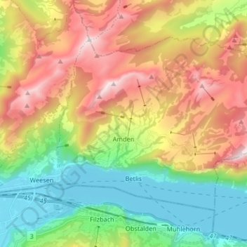
Name: Amden topographic map, elevation, terrain.
Location: Amden, Wahlkreis See-Gaster, St. Gallen, 8873, Schweiz (47.12370 9.10596 47.18679 9.23797)
Average elevation: 1,052 m
Minimum elevation: 416 m
Maximum elevation: 1,940 m
Make a donation
Gear up for your next adventure:
As an Amazon Associate, this site earns from qualifying purchases at no extra cost to you.
Other topographic maps
Click on a map to view its topography, its elevation and its terrain.
St. Gallenkappel
Schweiz > St. Gallen > Wahlkreis See-Gaster > Eschenbach (SG)
Average elevation: 581 m
Diemberg
Schweiz > St. Gallen > Wahlkreis See-Gaster > Eschenbach (SG) > Bürg
Average elevation: 647 m
Rinderweid
Schweiz > St. Gallen > Wahlkreis See-Gaster > Eschenbach (SG) > Hintergoldingen
Average elevation: 829 m
Make a donation
Gear up for your next adventure:
As an Amazon Associate, this site earns from qualifying purchases at no extra cost to you.
Gaster
Schweiz > St. Gallen > Wahlkreis See-Gaster > Maseltrangen > Oberdörfli
Average elevation: 471 m
Make a donation
Gear up for your next adventure:
As an Amazon Associate, this site earns from qualifying purchases at no extra cost to you.
Wurmsbach
Schweiz > St. Gallen > Wahlkreis See-Gaster > Rapperswil-Jona > Jona
Average elevation: 422 m
Töbeli
Schweiz > St. Gallen > Wahlkreis See-Gaster > Eschenbach (SG) > Hintergoldingen
Average elevation: 979 m
Make a donation
Gear up for your next adventure:
As an Amazon Associate, this site earns from qualifying purchases at no extra cost to you.
Make a donation
Gear up for your next adventure:
As an Amazon Associate, this site earns from qualifying purchases at no extra cost to you.