Geolocate

Kervily topographic map

Click on the map to display elevation.

About this map
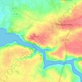
Name: Kervily topographic map, elevation, terrain.

Location: Kervily, Plouguerneau, Brest, Finistère, Bretagne, France métropolitaine, 29880, France (48.57825 -4.54395 48.61825 -4.50395)

Average elevation: 34 m

Minimum elevation: -1 m

Maximum elevation: 67 m

Other topographic maps

Click on a map to view its topography, its elevation and its terrain.

Île Vierge

France > Bretagne > Finistère > Plouguerneau

Average elevation: 0 m

Gear up for your next adventure:

🦯Trekking Poles - Reduced impact on joints for steep topographic climbs
🗺️Topographic Maps - Detailed maps to explore trails, mountains, and wilderness areas
🧦Outdoor Socks - Durable socks designed for hiking and outdoor sports
🥾Lightweight Hiking Boots - Boots for comfort and mobility on long hikes
💧Filtered Water Bottle - Safe drinking water on the go

As an Amazon Associate, this site earns from qualifying purchases at no extra cost to you.