Geolocate

Kikuyu topographic map

Click on the map to display elevation.

About this map

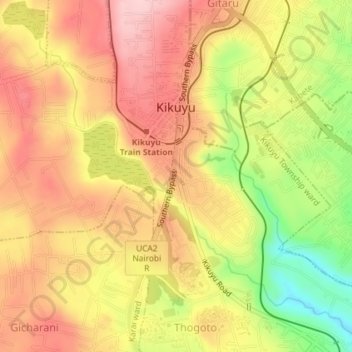
Name: Kikuyu topographic map, elevation, terrain.

Location: Kikuyu, Kiambu, 00109, Kenya (-1.26913 36.63916 -1.23287 36.67386)

Average elevation: 2,002 m

Minimum elevation: 1,884 m

Maximum elevation: 2,080 m

Other topographic maps

Click on a map to view its topography, its elevation and its terrain.

Kikuyu Township ward

Kenya > Kiambu > Kikuyu

Average elevation: 1,978 m

Mai A Ihii

Kenya > Kiambu > Kikuyu > Kikuyu

Average elevation: 2,016 m

Gicharani

Kenya > Kiambu > Kikuyu > Karai ward

Average elevation: 2,013 m

Gikambura

Kenya > Kiambu > Kikuyu > Karai ward

Average elevation: 2,014 m

Gear up for your next adventure:

🥾Trail Running Shoes - Lightweight and durable shoes for trail running
💧Hydration Pack - Hands-free hydration system for long hikes
🦌Outdoor Trail Camera - Monitor wildlife activity near your favorite spots
🥾Trekking Poles - Adjustable trekking poles to reduce knee stress and improve stability
💡Compact LED Flashlight - Powerful and portable flashlight for outdoor use

As an Amazon Associate, this site earns from qualifying purchases at no extra cost to you.