Geolocate

Kaytambog topographic map

Click on the map to display elevation.

About this map

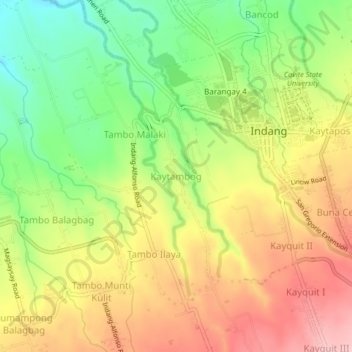
Name: Kaytambog topographic map, elevation, terrain.

Location: Kaytambog, Indang, Cavite, Calabarzon, 4122, Philippines (14.17061 120.84759 14.21061 120.88759)

Average elevation: 294 m

Minimum elevation: 207 m

Maximum elevation: 379 m

Other topographic maps

Click on a map to view its topography, its elevation and its terrain.

Bancod

Philippines > Cavite > Indang

Average elevation: 241 m

Banaba Cerca

Philippines > Cavite > Indang

Average elevation: 222 m

Kaytapos

Philippines > Cavite > Indang

Average elevation: 308 m

Gear up for your next adventure:

💧Collapsible Water Bottle - Space-saving water bottle for outdoor activities
🧥Thermal Fleece Jacket - Versatile insulation for changing mountain temperatures
🧥Softshell Jacket - Windproof and breathable jacket for hiking
🔭Outdoor Binoculars - Lightweight binoculars for birdwatching and hiking
🥾Trekking Boots - Durable boots for long-distance trekking

As an Amazon Associate, this site earns from qualifying purchases at no extra cost to you.