Geolocate

Tosca topographic map

Click on the map to display elevation.

About this map

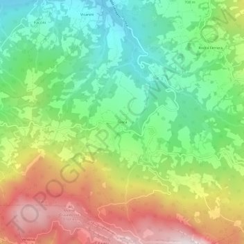
Name: Tosca topographic map, elevation, terrain.

Location: Tosca, Varsi, Parma, Emilia-Romagna, Italy (44.60429 9.79250 44.64429 9.83250)

Average elevation: 681 m

Minimum elevation: 340 m

Maximum elevation: 1,183 m

Gear up for your next adventure:

🧥Thermal Layer - Insulating layer for cold outdoor conditions
🧣Evaporative Cooling Towel - Beat the heat during intense summer climbs
🦯Trekking Poles - Reduced impact on joints for steep topographic climbs
🧢Sun Protection Cap - Breathable cap to protect from sun exposure
🥾Approach Boots - Comfortable boots for hiking and climbing approaches

As an Amazon Associate, this site earns from qualifying purchases at no extra cost to you.