Geolocate

Billericay topographic map

Click on the map to display elevation.

About this map

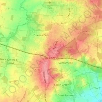
Name: Billericay topographic map, elevation, terrain.

Location: Billericay, Basildon, Essex, England, United Kingdom (51.61242 0.38129 51.65124 0.46357)

Average elevation: 63 m

Minimum elevation: 16 m

Maximum elevation: 101 m

Other topographic maps

Click on a map to view its topography, its elevation and its terrain.

Clacton-on-Sea

United Kingdom > England > Essex > Tendring

Average elevation: 7 m

Chelmsford

United Kingdom > England > Essex > Chelmsford

Average elevation: 53 m

Tendring Heath

United Kingdom > England > Essex > Tendring Heath

Average elevation: 29 m

Lodge Lake

United Kingdom > England > Essex > Chelmsford

Average elevation: 62 m

Stanford-le-Hope

United Kingdom > England > Essex

Average elevation: 17 m

Gear up for your next adventure:

🧭GPS Handheld Device - Reliable GPS navigation for outdoor adventures
🧢Sun Protection Cap - Breathable cap to protect from sun exposure
🔦LED Headtorch - Bright and durable light for night activities
🚲Handlebar Phone Mount - View topographic-map.com live while cycling
🧦Merino Wool Socks - Moisture-wicking comfort for long-distance hiking

As an Amazon Associate, this site earns from qualifying purchases at no extra cost to you.