Geolocate

Busca-Vida topographic map

Click on the map to display elevation.

About this map

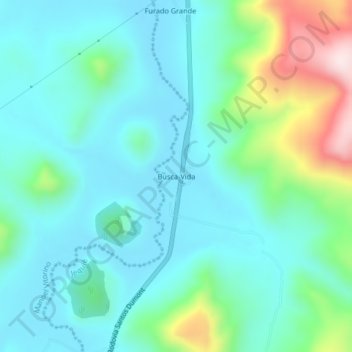
Name: Busca-Vida topographic map, elevation, terrain.

Location: Busca-Vida, Boaçu, Jequié, Bahia, Região Nordeste, Brasil (-14.07949 -40.22550 -14.03949 -40.18550)

Average elevation: 385 m

Minimum elevation: 276 m

Maximum elevation: 777 m

Other topographic maps

Click on a map to view its topography, its elevation and its terrain.

Monte Branco

Brasil > Bahia > Jequié

Average elevation: 549 m

Monte Branco

Brasil > Bahia > Jequié

Average elevation: 549 m

Gear up for your next adventure:

🧢Hiking Hat - Sun-protective and breathable hats for long treks
🧴Waterproofing Spray - Restore the DWR coating on jackets and tents
🔭Outdoor Binoculars - Lightweight binoculars for birdwatching and hiking
🥾Light Trekking Boots - Supportive boots for multi-day treks
💧Hydration Bladder - Hands-free hydration solution for long treks

As an Amazon Associate, this site earns from qualifying purchases at no extra cost to you.