Geolocate

Kambre topographic map

Click on the map to display elevation.

About this map

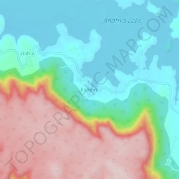
Name: Kambre topographic map, elevation, terrain.

Location: Kambre, Mawal, Pune, Maharashtra, India (18.86977 73.47428 18.90977 73.51428)

Average elevation: 786 m

Minimum elevation: 654 m

Maximum elevation: 1,007 m

Other topographic maps

Click on a map to view its topography, its elevation and its terrain.

Patan

India > Maharashtra > Mawal

Average elevation: 689 m

Kasarsai

India > Maharashtra > Mawal > Pachane

Average elevation: 654 m

Tung Fort

India > Maharashtra > Mawal

Average elevation: 733 m

Tikona Fort

India > Maharashtra > Mawal > Tikona Peth

Average elevation: 742 m

Pavana Dam

India > Maharashtra > Mawal > Kale Colony

Average elevation: 610 m

Gear up for your next adventure:

🔋Lithium AA Batteries - Long-lasting power that performs in extreme cold
🥾Trail Hiking Boots - Supportive boots for rough trails
Bushcraft Tarp - Versatile emergency shelter or gear protection
🛌Insulated Sleeping Pad - Critical thermal barrier between you and the cold ground
🧣Evaporative Cooling Towel - Beat the heat during intense summer climbs

As an Amazon Associate, this site earns from qualifying purchases at no extra cost to you.