
Wollongong topographic map
Interactive map
Click on the map to display elevation.
About this map
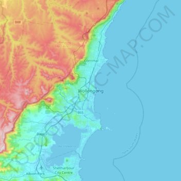
Name: Wollongong topographic map, elevation, terrain.
Location: Wollongong, Nouvelle Galles du Sud, 2500, Australie (-34.58439 150.73385 -34.26439 151.05385)
Average elevation: 115 m
Minimum elevation: -2 m
Maximum elevation: 590 m
Other topographic maps
Click on a map to view its topography, its elevation and its terrain.
Illawarra
Australie > Nouvelle Galles du Sud > Wollongong
Illawarra, Wollongong, Nouvelle Galles du Sud, Australie
Average elevation: 234 m