Geolocate

Cecina topographic map

Click on the map to display elevation.

About this map

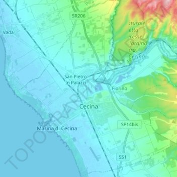
Name: Cecina topographic map, elevation, terrain.

Location: Cecina, Livorno, Tuscany, 57023, Italy (43.27350 10.46227 43.36799 10.58186)

Average elevation: 28 m

Minimum elevation: -3 m

Maximum elevation: 221 m

Other topographic maps

Click on a map to view its topography, its elevation and its terrain.

Baratti

Italy > Tuscany > Livorno > Piombino

Average elevation: 20 m

Punta delle Grotte

Italy > Tuscany > Livorno > Portoferraio

Average elevation: 68 m

Populonia Stazione

Italy > Tuscany > Livorno > Piombino

Average elevation: 11 m

Poggio Fortino

Italy > Tuscany > Livorno > Bagnaia

Average elevation: 29 m

Venturina Terme

Italy > Tuscany > Livorno > Campiglia Marittima

Average elevation: 28 m

Gear up for your next adventure:

Camping Groundsheet - Protect your tent from moisture and dirt
🛁Quick-Dry Microfiber Towel - Space-saving towel that dries rapidly on the move
🚲Heavy Duty Bike Lock - Secure your bike at the trailhead or during stops
🥾Trail Hiking Socks - Comfortable socks to prevent blisters and fatigue
🥾Waterproof Hiking Boots - Essential footwear for rugged terrain and wet Canadian trails

As an Amazon Associate, this site earns from qualifying purchases at no extra cost to you.