
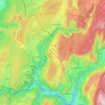
La Semine topographic map
Interactive map
Click on the map to display elevation.
About this map
Name: La Semine topographic map, elevation, terrain.
Average elevation: 901 m
Minimum elevation: 384 m
Maximum elevation: 1,616 m
Other topographic maps
Click on a map to view its topography, its elevation and its terrain.
La Gouille
France > Auvergne-Rhône-Alpes > Ain > Belleydoux
La Gouille, Belleydoux, Nantua, Ain, Auvergne-Rhône-Alpes, France métropolitaine, 01130, France
Average elevation: 902 m
Gobet
France > Auvergne-Rhône-Alpes > Ain > Belleydoux
Gobet, Belleydoux, Nantua, Ain, Auvergne-Rhône-Alpes, France métropolitaine, 01130, France
Average elevation: 957 m
Bas Belleydoux
France > Auvergne-Rhône-Alpes > Ain > Belleydoux > Bas Belleydoux
Bas Belleydoux, Belleydoux, Nantua, Ain, Auvergne-Rhône-Alpes, France métropolitaine, 01130, France
Average elevation: 936 m