Geolocate

Nilackal topographic map

Click on the map to display elevation.

About this map

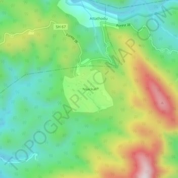
Name: Nilackal topographic map, elevation, terrain.

Location: Nilackal, Konni, Pathanamthitta District, Kerala, India (9.36957 76.99374 9.40957 77.03374)

Average elevation: 355 m

Minimum elevation: 121 m

Maximum elevation: 768 m

Other topographic maps

Click on a map to view its topography, its elevation and its terrain.

Aruvappulam

India > Kerala > Konni

Average elevation: 519 m

Gurunathanmannu

India > Kerala > Konni

Average elevation: 724 m

Gear up for your next adventure:

🔦UV Flashlight - Detect minerals or specific insects in the dark
Lightweight Camping Tent - Portable shelter optimized for Canadian backcountry camping
🧴First Aid Kit - Essential first aid supplies for outdoor emergencies
🛌Down Sleeping Bag - Superior warmth-to-weight ratio for cold nights
🧦Crew Hiking Socks - Comfortable socks for long-distance hikes

As an Amazon Associate, this site earns from qualifying purchases at no extra cost to you.