Geolocate

Cervia topographic map

Click on the map to display elevation.

About this map

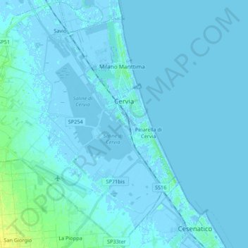
Name: Cervia topographic map, elevation, terrain.

Location: Cervia, Ravenna, Emilia-Romagna, 48015, Italy (44.19063 12.23011 44.30921 12.38397)

Average elevation: 1 m

Minimum elevation: -6 m

Maximum elevation: 18 m

Gear up for your next adventure:

🥾Trail Running Shoes - Lightweight and durable shoes for trail running
🧢Sun Protection Cap - Breathable cap to protect from sun exposure
🏕️Camping Hammock - Integrated protection for sleeping between trees
🥾Light Hiking Boots - Lightweight and comfortable boots for day hikes
🥾Light Trekking Boots - Supportive boots for multi-day treks

As an Amazon Associate, this site earns from qualifying purchases at no extra cost to you.