
Thuringian Forest topographic map
Interactive map
Click on the map to display elevation.
About this map
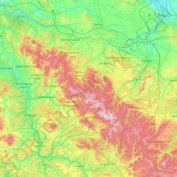
Name: Thuringian Forest topographic map, elevation, terrain.
Average elevation: 447 m
Minimum elevation: 173 m
Maximum elevation: 975 m
The Thuringian Forest forms a continuous chain of ancient rounded mountains with steep slopes to both sides and poses ample difficulties in transit routing save through a few navigable passes. It is about 70 km (43 mi) long and 20 km (12 mi) wide. The highest elevation is Großer Beerberg at 982 m (3,222 ft) a.s.l.