
Jackson Hole topographic map
Interactive map
Click on the map to display elevation.
About this map
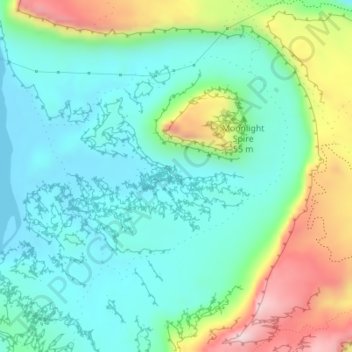
Name: Jackson Hole topographic map, elevation, terrain.
Location: Jackson Hole, Grand County, Utah, United States of America (38.50567 -109.64401 38.52567 -109.62401)
Average elevation: 1,313 m
Minimum elevation: 1,200 m
Maximum elevation: 1,591 m
Other topographic maps
Click on a map to view its topography, its elevation and its terrain.
Tropic
United States of America > Utah > Tropic
Tropic, Garfield County, Utah, 84776, United States of America
Average elevation: 1,997 m
Horizon Heights
United States of America > Utah > Herriman > Horizon Heights
Horizon Heights, Herriman, Salt Lake County, Utah, 84096, United States of America
Average elevation: 1,469 m
Stansbury Park
United States of America > Utah
Stansbury Park, Utah, United States of America
Average elevation: 1,319 m
Tooele
United States of America > Utah > Tooele
Tooele, Tooele County, Utah, 84074, United States of America
Average elevation: 1,610 m
Horsely
United States of America > Utah > Bountiful
Horsely, Bountiful, Davis County, Utah, 84010, United States of America
Average elevation: 1,440 m
Vista Plat
United States of America > Utah > West Jordan > Vista Plat
Vista Plat, West Jordan, Salt Lake County, Utah, 84088, United States of America
Average elevation: 1,404 m
Sawtooth
United States of America > Utah
Sawtooth, Sevier County, Utah, United States of America
Average elevation: 2,069 m
Hight
United States of America > Utah > Farmington > Hight
Hight, Farmington, Davis County, Utah, 84025, United States of America
Average elevation: 1,463 m
Central
United States of America > Utah > Central
Central, Washington County, Utah, 84722, United States of America
Average elevation: 1,636 m
Tithing Mountain
United States of America > Utah
Tithing Mountain, Utah County, Utah, 84641, United States of America
Average elevation: 1,617 m
Hi Country Estates
United States of America > Utah > Hi Country Estates
Hi Country Estates, Salt Lake County, Utah, United States of America
Average elevation: 1,649 m
Springdale
United States of America > Utah > Springdale > Springdale
Springdale, Washington County, Utah, 84767-0189, United States of America
Average elevation: 1,392 m
Canyon Village
United States of America > Utah > Sandy
Canyon Village, Sandy, Salt Lake County, Utah, 84094, United States of America
Average elevation: 1,459 m
Sandy
United States of America > Utah > Sandy
Sandy, Salt Lake County, Utah, 84092, United States of America
Average elevation: 1,827 m
Wendover
United States of America > Utah > Wendover
Wendover, Tooele County, Utah, 84083, United States of America
Average elevation: 1,399 m
Bowthorpe
United States of America > Utah > Holladay
Bowthorpe, Holladay, Salt Lake County, Utah, 84117, United States of America
Average elevation: 1,419 m