
Make a donation
Gear up for your next adventure:
As an Amazon Associate, this site earns from qualifying purchases at no extra cost to you.
Santo Antão topographic map
Click on the map to display elevation.
Make a donation
Gear up for your next adventure:
As an Amazon Associate, this site earns from qualifying purchases at no extra cost to you.
Santo Antão
Santo Antão is 42.75 km (26.56 mi) long (east-west) and 23.97 km (14.89 mi) wide (north-south). The island is of volcanic origin and very mountainous, characterized by two high plateaus and several steep river valleys. The southern part of the island has a desert climate, while the northeast and the higher elevations are semi-arid.
Make a donation
Gear up for your next adventure:
As an Amazon Associate, this site earns from qualifying purchases at no extra cost to you.
About this map
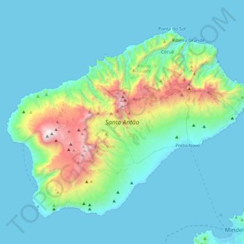
Name: Santo Antão topographic map, elevation, terrain.
Location: Santo Antão, Porto Novo, Cape Verde (16.90573 -25.36095 17.20531 -24.96302)
Average elevation: 286 m
Minimum elevation: -1 m
Maximum elevation: 1,972 m
Make a donation
Gear up for your next adventure:
As an Amazon Associate, this site earns from qualifying purchases at no extra cost to you.