Geolocate

Banjarsari topographic map

Click on the map to display elevation.

About this map

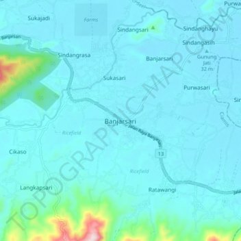
Name: Banjarsari topographic map, elevation, terrain.

Location: Banjarsari, Ciamis, West Java, Java, Indonesia (-7.52866 108.57514 -7.44866 108.65514)

Average elevation: 44 m

Minimum elevation: 8 m

Maximum elevation: 390 m

Other topographic maps

Click on a map to view its topography, its elevation and its terrain.

Ciamis

Indonesia > West Java > Ciamis

Ciamis Regency consists of 328 villages, with the topography predominantly characterized by 153 villages in the plains, 162 villages on the slopes, and 13 villages in the Watershed (DAS) area.

Average elevation: 217 m

Linggasari

Indonesia > West Java > Ciamis > Ciamis

Average elevation: 218 m

Cikoneng

Indonesia > West Java > Ciamis

Average elevation: 492 m

Bojongmengger

Indonesia > West Java > Ciamis

Average elevation: 118 m

Gear up for your next adventure:

🧼Travel Hand Sanitizer - Keep hands clean when water is scarce
🦶Hiking Shoe Insoles - Added support for high arches and long days on feet
🍽️Titanium Camping Spork - Ultralight and indestructible eating utensil
🧶550 Survival Paracord - Versatile utility cord for emergency repairs and rigging
🥾Approach Shoes - Shoes designed for climbing approaches and rugged trails

As an Amazon Associate, this site earns from qualifying purchases at no extra cost to you.