Geolocate

Ixtapaluca topographic map

Click on the map to display elevation.

About this map

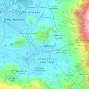
Name: Ixtapaluca topographic map, elevation, terrain.

Location: Ixtapaluca, State of Mexico, 56535, Mexico (19.15293 -99.04405 19.47293 -98.72405)

Average elevation: 2,507 m

Minimum elevation: 2,224 m

Maximum elevation: 4,107 m

Gear up for your next adventure:

🔋Lithium AA Batteries - Long-lasting power that performs in extreme cold
🥾Trail Hiking Socks - Comfortable socks to prevent blisters and fatigue
💡Compact LED Flashlight - Powerful and portable flashlight for outdoor use
🔨Vehicle Emergency Tool - Safety tool for remote road trips to trailheads
🧢Hiking Hat - Sun-protective and breathable hats for long treks

As an Amazon Associate, this site earns from qualifying purchases at no extra cost to you.