
Make a donation
Gear up for your next adventure:
As an Amazon Associate, this site earns from qualifying purchases at no extra cost to you.
Edapally topographic map
Click on the map to display elevation.
Make a donation
Gear up for your next adventure:
As an Amazon Associate, this site earns from qualifying purchases at no extra cost to you.
About this map
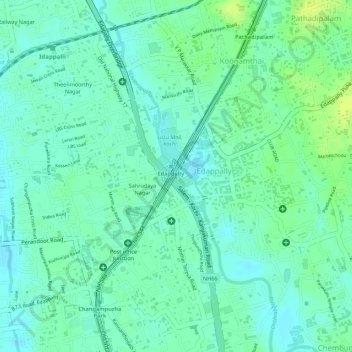
Name: Edapally topographic map, elevation, terrain.
Location: Edapally, Kanayannur, Ernakulam district, Kerala, India (10.01887 76.30304 10.03057 76.31402)
Average elevation: 9 m
Minimum elevation: 1 m
Maximum elevation: 18 m
Make a donation
Gear up for your next adventure:
As an Amazon Associate, this site earns from qualifying purchases at no extra cost to you.
Other topographic maps
Click on a map to view its topography, its elevation and its terrain.
Thrippunithura
India > Kerala > Kanayannur
In the south, Thrippunithura borders the Vembanad, the longest lake in India. The lake provides facilities for inland water navigation, with the Champakkara canal stretch of the National Waterway 3 forming its western boundary with Kochi and Maradu. The canal then merges with the Chithrapuzha river in the…
Average elevation: 8 m
Make a donation
Gear up for your next adventure:
As an Amazon Associate, this site earns from qualifying purchases at no extra cost to you.
Make a donation
Gear up for your next adventure:
As an Amazon Associate, this site earns from qualifying purchases at no extra cost to you.