
Make a donation
Gear up for your next adventure:
As an Amazon Associate, this site earns from qualifying purchases at no extra cost to you.
Bärensee topographic map
Click on the map to display elevation.
Make a donation
Gear up for your next adventure:
As an Amazon Associate, this site earns from qualifying purchases at no extra cost to you.
About this map
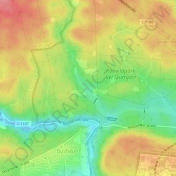
Name: Bärensee topographic map, elevation, terrain.
Average elevation: 446 m
Minimum elevation: 402 m
Maximum elevation: 487 m
Make a donation
Gear up for your next adventure:
As an Amazon Associate, this site earns from qualifying purchases at no extra cost to you.
Other topographic maps
Click on a map to view its topography, its elevation and its terrain.
Make a donation
Gear up for your next adventure:
As an Amazon Associate, this site earns from qualifying purchases at no extra cost to you.
Feuerbach
Deutschland > Baden-Württemberg > Stuttgart
Der Lemberg ist eine 384 Meter hohe Anhöhe zwischen den Stuttgarter Stadtbezirken Weilimdorf und Feuerbach. Dort gibt es auch einen kleinen alten Steinbruch, im Volksmund „Kotzenloch“ genannt.
Average elevation: 318 m