
Make a donation
Gear up for your next adventure:
As an Amazon Associate, this site earns from qualifying purchases at no extra cost to you.
Galilea topographic map
Click on the map to display elevation.
Make a donation
Gear up for your next adventure:
As an Amazon Associate, this site earns from qualifying purchases at no extra cost to you.
Galilea
Galilea liegt etwa 23 km (Fahrtstrecke) ostsüdöstlich der Provinzhauptstadt Logroño in einer Höhe von ca. 560 m. Das Klima ist gemäßigt bis warm; Regen (ca. 683 mm/Jahr) fällt überwiegend im Winterhalbjahr.
Make a donation
Gear up for your next adventure:
As an Amazon Associate, this site earns from qualifying purchases at no extra cost to you.
About this map
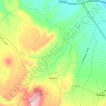
Name: Galilea topographic map, elevation, terrain.
Location: Galilea, La Rioja, Spanien (42.33182 -2.26040 42.39166 -2.19909)
Average elevation: 524 m
Minimum elevation: 389 m
Maximum elevation: 738 m
Make a donation
Gear up for your next adventure:
As an Amazon Associate, this site earns from qualifying purchases at no extra cost to you.
Other topographic maps
Click on a map to view its topography, its elevation and its terrain.