Geolocate

Reddomain topographic map

Click on the map to display elevation.

About this map

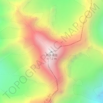
Name: Reddomain topographic map, elevation, terrain.

Location: Reddomain, Kangding, Kardze, Sichuan, 626000, China (29.73325 101.83767 29.73335 101.83777)

Average elevation: 5,352 m

Minimum elevation: 4,639 m

Maximum elevation: 6,090 m

Other topographic maps

Click on a map to view its topography, its elevation and its terrain.

贡巴冰川

China > Sichuan > Kangding

Average elevation: 5,375 m

康定跑马山风景区

China > Sichuan > Kangding > Jingangsi

Average elevation: 2,804 m

Gear up for your next adventure:

🧴Outdoor Sunscreen - High SPF protection for high-altitude UV exposure
🧰Emergency Multi-Tool - Compact multi-tool for outdoor survival
👟Trail Running Shoes - Agile footwear for fast-paced topographic exploration
🥾Trail Hiking Boots - Supportive boots for rough trails
🧦Merino Wool Socks - Moisture-wicking comfort for long-distance hiking

As an Amazon Associate, this site earns from qualifying purchases at no extra cost to you.