
Make a donation
Gear up for your next adventure:
As an Amazon Associate, this site earns from qualifying purchases at no extra cost to you.
Reutlingen-Betzingen topographic map
Click on the map to display elevation.
Make a donation
Gear up for your next adventure:
As an Amazon Associate, this site earns from qualifying purchases at no extra cost to you.
About this map
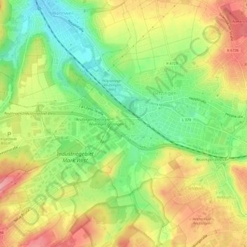
Name: Reutlingen-Betzingen topographic map, elevation, terrain.
Average elevation: 376 m
Minimum elevation: 323 m
Maximum elevation: 430 m
Make a donation
Gear up for your next adventure:
As an Amazon Associate, this site earns from qualifying purchases at no extra cost to you.
Other topographic maps
Click on a map to view its topography, its elevation and its terrain.
Degerschlacht
Deutschland > Baden-Württemberg > Landkreis Reutlingen > Reutlingen
Average elevation: 376 m
Gönningen
Deutschland > Baden-Württemberg > Landkreis Reutlingen > Reutlingen
Average elevation: 608 m
Sickenhausen
Deutschland > Baden-Württemberg > Landkreis Reutlingen > Reutlingen
Average elevation: 370 m