
Nes, Eysturoy topographic map
Interactive map
Click on the map to display elevation.
About this map
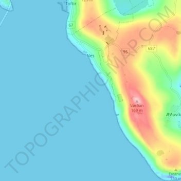
Name: Nes, Eysturoy topographic map, elevation, terrain.
Location: Nes, Eysturoy, Eysturoy region, 655, Faroe Islands (62.05596 -6.73968 62.09225 -6.69041)
Average elevation: 33 m
Minimum elevation: -47 m
Maximum elevation: 164 m
Other topographic maps
Click on a map to view its topography, its elevation and its terrain.
Eysturoy
Faroe Islands > Eysturoy region
Eysturoy, Eysturoy region, Faroe Islands
Average elevation: 162 m
Saltnes
Faroe Islands > Eysturoy region
Saltnes, Eysturoy region, 656, Faroe Islands
Average elevation: 30 m