
Make a donation
Gear up for your next adventure:
As an Amazon Associate, this site earns from qualifying purchases at no extra cost to you.
Rivière Madeleine topographic map
Click on the map to display elevation.
Make a donation
Gear up for your next adventure:
As an Amazon Associate, this site earns from qualifying purchases at no extra cost to you.
About this map
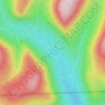
Name: Rivière Madeleine topographic map, elevation, terrain.
Average elevation: 753 m
Minimum elevation: 541 m
Maximum elevation: 1,031 m
Make a donation
Gear up for your next adventure:
As an Amazon Associate, this site earns from qualifying purchases at no extra cost to you.
Other topographic maps
Click on a map to view its topography, its elevation and its terrain.
Gaspésie
Canada > Québec > La Haute-Gaspésie > Mont-Albert
La Côte se déroule de Sainte-Flavie aux Méchins le long de l'estuaire du Saint-Laurent en décrivant une immense courbe. Matane, dont l'altitude moyenne est de 160 m, est la plus grande ville de cette région. Trois rivières se jettent dans le Saint-Laurent et traversent perpendiculairement le paysage :…
Average elevation: 459 m