Geolocate

Chazca topographic map

Click on the map to display elevation.

About this map

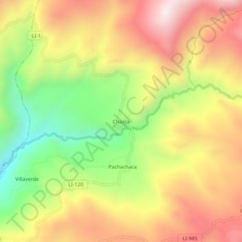
Name: Chazca topographic map, elevation, terrain.

Location: Chazca, Calamarca, Julcán, La Libertad, Perú (-8.09812 -78.40516 -8.05812 -78.36516)

Average elevation: 3,482 m

Minimum elevation: 3,042 m

Maximum elevation: 3,883 m

Gear up for your next adventure:

💡LED Camping Lantern - Illuminate your campsite with long-lasting lanterns
🩹Moleskin Blister Pads - Direct protection for painful foot pressure points
🧶550 Survival Paracord - Versatile utility cord for emergency repairs and rigging
🧴Outdoor Sunscreen - High SPF protection for high-altitude UV exposure
🎒Backpack Rain Cover - External shield to keep your entire pack dry

As an Amazon Associate, this site earns from qualifying purchases at no extra cost to you.