
Thank you for supporting this site ❤️
Make a donation
Make a donation
Gear up for your next adventure:
As an Amazon Associate, this site earns from qualifying purchases at no extra cost to you.
Nutria topographic map
Click on the map to display elevation.
Thank you for supporting this site ❤️
Make a donation
Make a donation
Gear up for your next adventure:
As an Amazon Associate, this site earns from qualifying purchases at no extra cost to you.
About this map
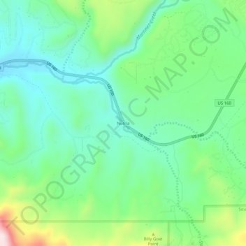
Name: Nutria topographic map, elevation, terrain.
Location: Nutria, Archuleta County, Colorado, 81147, United States (37.21084 -107.14560 37.25084 -107.10560)
Average elevation: 2,242 m
Minimum elevation: 2,122 m
Maximum elevation: 2,542 m
Thank you for supporting this site ❤️
Make a donation
Make a donation
Gear up for your next adventure:
As an Amazon Associate, this site earns from qualifying purchases at no extra cost to you.
Other topographic maps
Click on a map to view its topography, its elevation and its terrain.
Rio Grande, Pagosa, and Northern Railroad
United States > Colorado > Archuleta County
Average elevation: 2,258 m