
Make a donation
Gear up for your next adventure:
As an Amazon Associate, this site earns from qualifying purchases at no extra cost to you.
Oujda topographic map
Click on the map to display elevation.
Make a donation
Gear up for your next adventure:
As an Amazon Associate, this site earns from qualifying purchases at no extra cost to you.
Oujda
À six kilomètres d'Oujda, l'oasis de Sidi Yahya englobe un souk les vendredis matin. La capitale du Maroc Oriental située à 450 m d'altitude offre palmiers, eucalyptus, mimosas, lilas, un enchantement pour les sens. La médina demeure strictement traditionnelle.
Make a donation
Gear up for your next adventure:
As an Amazon Associate, this site earns from qualifying purchases at no extra cost to you.
About this map
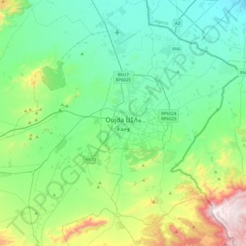
Name: Oujda topographic map, elevation, terrain.
Average elevation: 660 m
Minimum elevation: 388 m
Maximum elevation: 1,580 m
Make a donation
Gear up for your next adventure:
As an Amazon Associate, this site earns from qualifying purchases at no extra cost to you.