
Make a donation
Gear up for your next adventure:
As an Amazon Associate, this site earns from qualifying purchases at no extra cost to you.
Natural Bridge Station topographic map
Click on the map to display elevation.
Make a donation
Gear up for your next adventure:
As an Amazon Associate, this site earns from qualifying purchases at no extra cost to you.
About this map
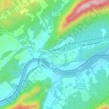
Name: Natural Bridge Station topographic map, elevation, terrain.
Average elevation: 288 m
Minimum elevation: 212 m
Maximum elevation: 537 m
Make a donation
Gear up for your next adventure:
As an Amazon Associate, this site earns from qualifying purchases at no extra cost to you.
Other topographic maps
Click on a map to view its topography, its elevation and its terrain.
Goshen Scout Reservation
United States > Virginia > Rockbridge County
The first year camper program, called Bowman Brigade, focuses on the rank requirements of Scout, Tenderfoot, Second Class, and First Class. Staff introduce participants to different merit badges. The older Scout program with an age requirement of 14, called Bowman Vets, focuses on wakeboarding, action archery,…
Average elevation: 510 m
Make a donation
Gear up for your next adventure:
As an Amazon Associate, this site earns from qualifying purchases at no extra cost to you.
Make a donation
Gear up for your next adventure:
As an Amazon Associate, this site earns from qualifying purchases at no extra cost to you.