
Make a donation
Gear up for your next adventure:
As an Amazon Associate, this site earns from qualifying purchases at no extra cost to you.
Mauer topographic map
Click on the map to display elevation.
Make a donation
Gear up for your next adventure:
As an Amazon Associate, this site earns from qualifying purchases at no extra cost to you.
Mauer
Mauer is located at an altitude of 130–240 m, and covers an area of 630 hectares. Of this area, 22.8% is covered by settlements, roads and paved areas, 55.3% is agricultural, and 18.6% is forested. Adjacent municipalities are, starting in the north and moving clockwise, Wiesenbach, Meckesheim, Wiesloch, Leimen and Bammental.
Make a donation
Gear up for your next adventure:
As an Amazon Associate, this site earns from qualifying purchases at no extra cost to you.
About this map
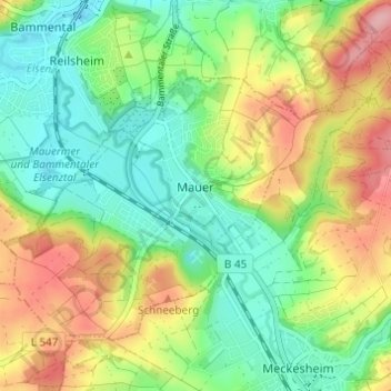
Name: Mauer topographic map, elevation, terrain.
Average elevation: 175 m
Minimum elevation: 123 m
Maximum elevation: 254 m
Make a donation
Gear up for your next adventure:
As an Amazon Associate, this site earns from qualifying purchases at no extra cost to you.
Other topographic maps
Click on a map to view its topography, its elevation and its terrain.
Sinsheim-Steinsfurt / Insenbach
Germany > Baden-Württemberg > Rhein-Neckar-Kreis > Sinsheim
Average elevation: 204 m
Gauangelloch
Germany > Baden-Württemberg > Rhein-Neckar-Kreis > Leimen > Gauangelloch
Average elevation: 221 m
Neckar-Wimmersbach
Germany > Baden-Württemberg > Rhein-Neckar-Kreis > Eberbach
Average elevation: 256 m