Geolocate

Dalmore topographic map

Click on the map to display elevation.

About this map

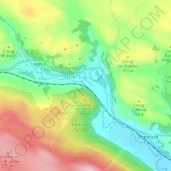
Name: Dalmore topographic map, elevation, terrain.

Location: Dalmore, Rogart, Highland, Scotland, IV28 3UA, United Kingdom (57.98099 -4.20384 58.02099 -4.16384)

Average elevation: 118 m

Minimum elevation: 3 m

Maximum elevation: 296 m

Other topographic maps

Click on a map to view its topography, its elevation and its terrain.

Loch Ness

United Kingdom > Scotland > Highland > Dores

Average elevation: 340 m

Strathnairn

United Kingdom > Scotland > Highland > Daviot

Average elevation: 268 m

Whitebridge

United Kingdom > Scotland > Highland

Average elevation: 223 m

Glen Coe

United Kingdom > Scotland > Highland > Glencoe

Average elevation: 414 m

Gear up for your next adventure:

🚑Survival Whistle - Signal for help across long distances in mountains
🛌Down Sleeping Bag - Superior warmth-to-weight ratio for cold nights
🧴First Aid Kit - Essential first aid supplies for outdoor emergencies
🔨Vehicle Emergency Tool - Safety tool for remote road trips to trailheads
🕶️Polarized Sunglasses - Reduces glare from snow and water at high elevations

As an Amazon Associate, this site earns from qualifying purchases at no extra cost to you.