
Brighton topographic map
Click on the map to display elevation.
Brighton
Brighton has a high-altitude cold continental climate (Köppen Dsb/Dsc), with dry summers and very snowy winters.
About this map
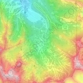
Name: Brighton topographic map, elevation, terrain.
Location: Brighton, Salt Lake County, Utah, United States (40.58182 -111.60331 40.62182 -111.56331)
Average elevation: 2,852 m
Minimum elevation: 2,487 m
Maximum elevation: 3,271 m
Other topographic maps
Click on a map to view its topography, its elevation and its terrain.
Bluffdale
United States > Utah > Salt Lake County
Bluffdale has an area of 10.22 square miles (26.47 km2) and an average elevation of 4,436 feet (1,352 m) above sea level. Bluffdale is predominately located in Salt Lake County, though a portion of the city is in Utah County. Bluffdale shares city borders with Herriman to the west, Riverton to the north,…
Average elevation: 1,468 m
Alta
United States > Utah > Salt Lake County
Alta experiences a high altitude humid continental climate (Köppen Dfb), which borders on a subalpine climate (Dfc), due to its high elevation. Due to its proximity to the Great Salt Lake, the town receives very heavy snows, averaging over 507 inches (12.9 m) per year. During the very wet season of 1982/1983,…
Average elevation: 2,912 m
South Valence Drainage
United States > Utah > Salt Lake County > West Jordan
Average elevation: 1,388 m