
Make a donation
Gear up for your next adventure:
As an Amazon Associate, this site earns from qualifying purchases at no extra cost to you.
Kirchleus topographic map
Click on the map to display elevation.
Make a donation
Gear up for your next adventure:
As an Amazon Associate, this site earns from qualifying purchases at no extra cost to you.
Kirchleus
Das Pfarrdorf liegt im tief eingeschnittenen Tal des Geretsbachs, der in den Leßbach mündet, einen linken Zufluss der Rodach. 1 km westlich befindet sich der Knock (513 m ü. NHN), 0,8 km nordöstlich der Stennesberg (512 m ü. NHN), beides Anhöhen der Kirchleuser Platte, die Teil des Obermainischen Hügellandes sind. Beim Stennesberg gibt es einen Baum, der als Naturdenkmal registriert ist. Im Wesentlichen ist der Ort von Acker- und Grünland umgeben.
Make a donation
Gear up for your next adventure:
As an Amazon Associate, this site earns from qualifying purchases at no extra cost to you.
About this map
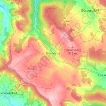
Name: Kirchleus topographic map, elevation, terrain.
Location: Kirchleus, Kulmbach, Landkreis Kulmbach, Bayern, Deutschland (50.15098 11.36634 50.19098 11.40634)
Average elevation: 452 m
Minimum elevation: 347 m
Maximum elevation: 524 m
Make a donation
Gear up for your next adventure:
As an Amazon Associate, this site earns from qualifying purchases at no extra cost to you.
Other topographic maps
Click on a map to view its topography, its elevation and its terrain.
95326
Deutschland > Bayern > Landkreis Kulmbach > Kulmbach > Ziegelhütten > Metzdorf
Average elevation: 394 m