Geolocate

Sassano topographic map

Click on the map to display elevation.

About this map

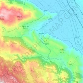
Name: Sassano topographic map, elevation, terrain.

Location: Sassano, Salerno, Campania, Italy (40.28350 15.51881 40.37385 15.62428)

Average elevation: 787 m

Minimum elevation: 446 m

Maximum elevation: 1,495 m

Other topographic maps

Click on a map to view its topography, its elevation and its terrain.

Marina di Vietri

Italy > Campania > Salerno > Vietri sul Mare

Average elevation: 141 m

Pogerola

Italy > Campania > Salerno

Average elevation: 363 m

Civitella

Italy > Campania > Salerno > Moio della Civitella

Average elevation: 614 m

Monte Cervati

Italy > Campania > Salerno > Sanza

Average elevation: 1,622 m

Catona

Italy > Campania > Salerno

Average elevation: 428 m

Iaconti

Italy > Campania > Salerno > Vietri sul Mare

Average elevation: 285 m

Erchie

Italy > Campania > Salerno > Maiori

Average elevation: 131 m

Ariano

Italy > Campania > Salerno

Average elevation: 281 m

Bosco

Italy > Campania > Salerno

Average elevation: 388 m

San Severino

Italy > Campania > Salerno > Centola

Average elevation: 273 m

Montepertuso

Italy > Campania > Salerno > Arienzo

Average elevation: 455 m

Gear up for your next adventure:

🧰Survival Kit - Essential gear for emergencies in the wilderness
🧥Waterproof Jacket - Lightweight rain jackets for hiking and outdoor activities
🛌Down Sleeping Bag - Superior warmth-to-weight ratio for cold nights
🧥Packable Rain Jacket - Breathable waterproof layer for unpredictable weather
🧭GPS Outdoor Watch - Smart watch for navigation and fitness tracking in nature

As an Amazon Associate, this site earns from qualifying purchases at no extra cost to you.