Geolocate

Sutri topographic map

Click on the map to display elevation.

About this map

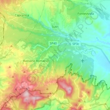
Name: Sutri topographic map, elevation, terrain.

Location: Sutri, Viterbo, Lazio, 01015, Italy (42.17748 12.18186 42.26907 12.29567)

Average elevation: 363 m

Minimum elevation: 242 m

Maximum elevation: 594 m

Other topographic maps

Click on a map to view its topography, its elevation and its terrain.

Monte Altieri

Italy > Lazio > Viterbo > Valentano

Average elevation: 493 m

Cura

Italy > Lazio > Viterbo > Vetralla

Average elevation: 393 m

Torre Alfina

Italy > Lazio > Viterbo > Acquapendente > Torre Alfina

Average elevation: 411 m

Gear up for your next adventure:

🧦Hiking Socks - Moisture-wicking and comfortable socks for long hikes
🧦Crew Hiking Socks - Comfortable socks for long-distance hikes
🛁Quick-Dry Microfiber Towel - Space-saving towel that dries rapidly on the move
🧢Outdoor Cap - Protective cap for sun and rain during hikes
🧥Waterproof Jacket - Lightweight rain jackets for hiking and outdoor activities

As an Amazon Associate, this site earns from qualifying purchases at no extra cost to you.