
Make a donation
Gear up for your next adventure:
As an Amazon Associate, this site earns from qualifying purchases at no extra cost to you.
Bad Sobernheim topographic map
Click on the map to display elevation.
Make a donation
Gear up for your next adventure:
As an Amazon Associate, this site earns from qualifying purchases at no extra cost to you.
Bad Sobernheim
Bad Sobernheim liegt an der mittleren Nahe, zentral zwischen der Kreisstadt Bad Kreuznach und der Edelsteinmetropole Idar-Oberstein. Nördlich erhebt sich der Hunsrück, südlich das Nordpfälzer Bergland. Das Stadtgebiet zieht sich bis zum Soonwald hin. Durch die wegen Fluglärm des ehemaligen Flugplatzes nach Sobernheim umgesiedelten Einwohner und die Eingliederung der Gemarkungen Eckweiler und Pferdsfeld in das Stadtgebiet von Sobernheim hat die Stadt seit 1979 einen weitgehend unbewohnten und durch das Gemeindegebiet von Nußbaum abgetrennten Teil auf den Nahehöhen.
Make a donation
Gear up for your next adventure:
As an Amazon Associate, this site earns from qualifying purchases at no extra cost to you.
About this map
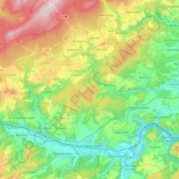
Name: Bad Sobernheim topographic map, elevation, terrain.
Average elevation: 315 m
Minimum elevation: 124 m
Maximum elevation: 638 m
Make a donation
Gear up for your next adventure:
As an Amazon Associate, this site earns from qualifying purchases at no extra cost to you.