
Villa El Salvador topographic map
Interactive map
Click on the map to display elevation.
About this map
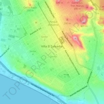
Name: Villa El Salvador topographic map, elevation, terrain.
Location: Villa El Salvador, Lima, Peru (-12.25256 -76.97716 -12.18247 -76.90961)
Average elevation: 104 m
Minimum elevation: -1 m
Maximum elevation: 401 m
Other topographic maps
Click on a map to view its topography, its elevation and its terrain.
V
Peru > Lima > Villa El Salvador
V, Sector 10 Grupo 3A, Villa El Salvador, Lima, Peru
Average elevation: 72 m