
Make a donation
Gear up for your next adventure:
As an Amazon Associate, this site earns from qualifying purchases at no extra cost to you.
Little Arkansaw topographic map
Click on the map to display elevation.
Make a donation
Gear up for your next adventure:
As an Amazon Associate, this site earns from qualifying purchases at no extra cost to you.
About this map
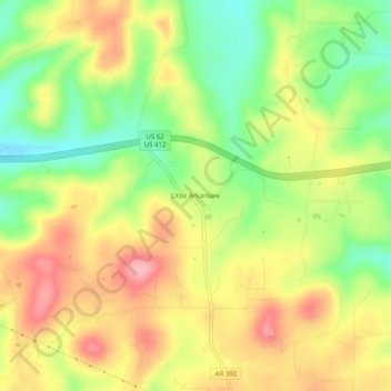
Name: Little Arkansaw topographic map, elevation, terrain.
Location: Little Arkansaw, Boone County, Arkansas, United States (36.26924 -93.25657 36.30924 -93.21657)
Average elevation: 435 m
Minimum elevation: 371 m
Maximum elevation: 496 m
Make a donation
Gear up for your next adventure:
As an Amazon Associate, this site earns from qualifying purchases at no extra cost to you.
Other topographic maps
Click on a map to view its topography, its elevation and its terrain.
Zinc
United States > Arkansas > Boone County
Zinc is in the Ozark region and has an elevation of 879 feet (268 m).
Average elevation: 324 m
Make a donation
Gear up for your next adventure:
As an Amazon Associate, this site earns from qualifying purchases at no extra cost to you.