
Make a donation
Gear up for your next adventure:
As an Amazon Associate, this site earns from qualifying purchases at no extra cost to you.
Bellville topographic map
Click on the map to display elevation.
Make a donation
Gear up for your next adventure:
As an Amazon Associate, this site earns from qualifying purchases at no extra cost to you.
About this map
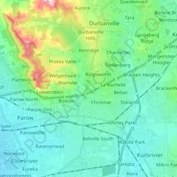
Name: Bellville topographic map, elevation, terrain.
Location: Bellville, City of Cape Town, Western Cape, South Africa (-33.94120 18.57766 -33.82513 18.67774)
Average elevation: 115 m
Minimum elevation: 28 m
Maximum elevation: 461 m
Make a donation
Gear up for your next adventure:
As an Amazon Associate, this site earns from qualifying purchases at no extra cost to you.
Other topographic maps
Click on a map to view its topography, its elevation and its terrain.
Zandvlei Estuary Nature Reserve
South Africa > Western Cape > City of Cape Town
Average elevation: 41 m
Make a donation
Gear up for your next adventure:
As an Amazon Associate, this site earns from qualifying purchases at no extra cost to you.
Cape Point
South Africa > Western Cape > City of Cape Town
The new lighthouse is at a lower elevation (87 meters; 285.5 feet above sea level), for two reasons: the old lighthouse, located at 34°21′12″S 18°29′25.2″E / 34.35333°S 18.490333°E / -34.35333; 18.490333 (262 meters; 859.6 feet above sea level), could be seen 'too early' by ships rounding…
Average elevation: 8 m
Silvermist Estate
South Africa > Western Cape > City of Cape Town > Cape Town
Average elevation: 272 m
Make a donation
Gear up for your next adventure:
As an Amazon Associate, this site earns from qualifying purchases at no extra cost to you.
Table Mountain (Maclear's beacon)
South Africa > Western Cape > City of Cape Town > Cape Town
Average elevation: 675 m
Make a donation
Gear up for your next adventure:
As an Amazon Associate, this site earns from qualifying purchases at no extra cost to you.
Cape Town Ward 98
South Africa > Western Cape > City of Cape Town > Khayelitsha
Average elevation: 27 m
Cape Town Ward 69
South Africa > Western Cape > City of Cape Town > Noordhoek
Average elevation: 137 m
Cape Town Ward 11
South Africa > Western Cape > City of Cape Town > Kuilsrivier
Average elevation: 58 m
Blaauwberg Nature Reserve
South Africa > Western Cape > City of Cape Town > Melkbosstrand
Average elevation: 46 m
Make a donation
Gear up for your next adventure:
As an Amazon Associate, this site earns from qualifying purchases at no extra cost to you.
Llandudno Beach
South Africa > Western Cape > City of Cape Town > Cape Town > Llandudno
Average elevation: 108 m
Cape Town Ward 111
South Africa > Western Cape > City of Cape Town > Kraaifontein
Average elevation: 109 m
Make a donation
Gear up for your next adventure:
As an Amazon Associate, this site earns from qualifying purchases at no extra cost to you.
Cape Town Ward 21
South Africa > Western Cape > City of Cape Town > Bellville
Average elevation: 132 m
Rietvlei Wetland Reserve
South Africa > Western Cape > City of Cape Town > Cape Town
Average elevation: 5 m
Make a donation
Gear up for your next adventure:
As an Amazon Associate, this site earns from qualifying purchases at no extra cost to you.