Geolocate

Kau To topographic map

Click on the map to display elevation.

About this map

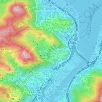
Name: Kau To topographic map, elevation, terrain.

Location: Kau To, Hong Kong, New Territories, China (22.39013 114.18257 22.43013 114.22257)

Average elevation: 106 m

Minimum elevation: -4 m

Maximum elevation: 384 m

Other topographic maps

Click on a map to view its topography, its elevation and its terrain.

New Territories

China > Hong Kong

Average elevation: 44 m

New Territories

China > Hong Kong

Average elevation: 44 m

New Territories

China > Hong Kong

Average elevation: 44 m

North District

China > Hong Kong

Average elevation: 115 m

Eastern District

China > Hong Kong

Average elevation: 84 m

Southern District

China > Hong Kong

Average elevation: 36 m

Cheung Chau

China > Hong Kong

Average elevation: 6 m

Tsing Chau

China > Hong Kong > Sai Lau Kong

Average elevation: 7 m

Wong Yue Tan

China > Hong Kong

Average elevation: 24 m

Mountains of Kowloon

China > Hong Kong

Average elevation: 92 m

Lantau

China > Hong Kong

Average elevation: 55 m

Discovery Bay

China > Hong Kong

Average elevation: 100 m

Long Harbour

China > Hong Kong

Average elevation: 21 m

Lantau

China > Hong Kong

Average elevation: 55 m

Yuen Long District

China > Hong Kong

Average elevation: 66 m

Lan Kwai Fong

China > Hong Kong

Average elevation: 136 m

Hong Kong Island

China > Hong Kong

Average elevation: 36 m

Gear up for your next adventure:

🦌Outdoor Trail Camera - Monitor wildlife activity near your favorite spots
🎒Backpack Rain Cover - External shield to keep your entire pack dry
Camping Groundsheet - Protect your tent from moisture and dirt
🥾Trail Hiking Socks - Comfortable socks to prevent blisters and fatigue
🏃Hydration Running Vest - Carry water and maps close to your body for speed

As an Amazon Associate, this site earns from qualifying purchases at no extra cost to you.