
Lewis County topographic map
Interactive map
Click on the map to display elevation.
About this map
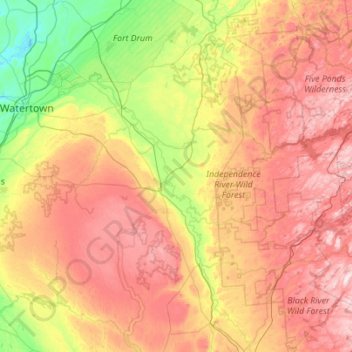
Name: Lewis County topographic map, elevation, terrain.
Location: Lewis County, New York, USA (43.41976 -75.85200 44.21944 -75.11016)
Average elevation: 385 m
Minimum elevation: 94 m
Maximum elevation: 780 m
Other topographic maps
Click on a map to view its topography, its elevation and its terrain.
Niagara Falls
USA > New York > Niagara Falls
Niagara Falls, Niagara County, New York, USA
Average elevation: 180 m
Avalanche Lake
Avalanche Lake, Avalanche Pass Trail, Essex County, New York, USA
Average elevation: 1,066 m
Flat Top Mountain
Flat Top Mountain, Franklin County, New York, USA
Average elevation: 568 m
Mount Warren
Mount Warren, Town of Bovina, Delaware County, New York, USA
Average elevation: 677 m
Buchanan
USA > New York > Buchanan > Town of Cortlandt
Buchanan, Town of Cortlandt, Westchester County, New York, 10511, USA
Average elevation: 27 m
Falls Creek
Falls Creek, Town of Delhi, Delaware County, New York, 13753, USA
Average elevation: 515 m
Sawtooth Mountains
Sawtooth Mountains, Franklin County, New York, USA
Average elevation: 927 m
Farmingville
USA > New York > Farmingville
Farmingville, Suffolk County, New York, 11738, USA
Average elevation: 47 m
North Western
USA > New York > North Western
North Western, Town of Western, Oneida County, New York, 13486, USA
Average elevation: 250 m
Livingston Island
Livingston Island, Town of Philipstown, Putnam County, New York, 10922, USA
Average elevation: 156 m