Geolocate

Attiggio topographic map

Click on the map to display elevation.

About this map

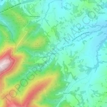
Name: Attiggio topographic map, elevation, terrain.

Location: Attiggio, Fabriano, Ancona, Marche, 60044, Italy (43.28540 12.90055 43.32540 12.94055)

Average elevation: 472 m

Minimum elevation: 312 m

Maximum elevation: 887 m

Gear up for your next adventure:

🦯Trekking Poles - Reduced impact on joints for steep topographic climbs
🧭Orienteering Kit - Tools for map reading and navigation in the wild
🛶Canoe Life Vest - Safety vest for water sports
🏃Hydration Running Vest - Carry water and maps close to your body for speed
Tent Footprint - Protect tent floor and increase durability

As an Amazon Associate, this site earns from qualifying purchases at no extra cost to you.