
Thank you for supporting this site ❤️
Make a donation
Make a donation
Gear up for your next adventure:
As an Amazon Associate, this site earns from qualifying purchases at no extra cost to you.
Aramaio topographic map
Click on the map to display elevation.
Thank you for supporting this site ❤️
Make a donation
Make a donation
Gear up for your next adventure:
As an Amazon Associate, this site earns from qualifying purchases at no extra cost to you.
About this map
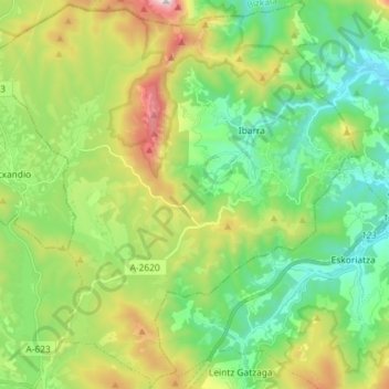
Name: Aramaio topographic map, elevation, terrain.
Location: Aramaio, Gorbeialdea, Alava, Pays basque autonome, Espagne (42.98225 -2.66124 43.08801 -2.52485)
Average elevation: 578 m
Minimum elevation: 231 m
Maximum elevation: 1,303 m
Thank you for supporting this site ❤️
Make a donation
Make a donation
Gear up for your next adventure:
As an Amazon Associate, this site earns from qualifying purchases at no extra cost to you.