
Make a donation
Gear up for your next adventure:
As an Amazon Associate, this site earns from qualifying purchases at no extra cost to you.
Nienstedt (Deister) topographic map
Click on the map to display elevation.
Make a donation
Gear up for your next adventure:
As an Amazon Associate, this site earns from qualifying purchases at no extra cost to you.
Nienstedt (Deister)
Nienstedt liegt von Wald umgeben mitten im Deister, einem Teil des Niedersächsischen Berglandes. Hindurch fließt der Waltershagener Bach. Das Dorf wird auch „Die Perle im Deister“ genannt und ist die einzige größere Ansiedlung, die innerhalb des Höhenzuges und nicht an seinen Rändern liegt. Die nächsten Ortschaften in der Nachbarschaft sind Eimbeckhausen im Südwesten, der Barsinghäuser Stadtteil Egestorf im Nordosten sowie die Schaumburger Ortsteile Messenkamp und Altenhagen II im Westen.
Make a donation
Gear up for your next adventure:
As an Amazon Associate, this site earns from qualifying purchases at no extra cost to you.
About this map
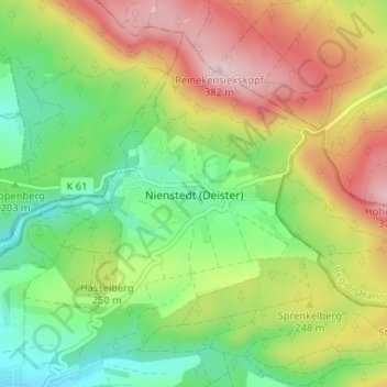
Name: Nienstedt (Deister) topographic map, elevation, terrain.
Average elevation: 237 m
Minimum elevation: 130 m
Maximum elevation: 380 m
Make a donation
Gear up for your next adventure:
As an Amazon Associate, this site earns from qualifying purchases at no extra cost to you.
Other topographic maps
Click on a map to view its topography, its elevation and its terrain.
Flegessen
Deutschland > Niedersachsen > Landkreis Hameln-Pyrmont > Bad Münder am Deister
Average elevation: 137 m
Bakede
Deutschland > Niedersachsen > Landkreis Hameln-Pyrmont > Bad Münder am Deister > Bakede
Average elevation: 237 m