
Make a donation
Gear up for your next adventure:
As an Amazon Associate, this site earns from qualifying purchases at no extra cost to you.
Dead Sea topographic map
Click on the map to display elevation.
Make a donation
Gear up for your next adventure:
As an Amazon Associate, this site earns from qualifying purchases at no extra cost to you.
Dead Sea
The lake's surface is 430.5 metres (1,412 ft) below sea level, making its shores the lowest land-based elevation on Earth. It is 304 m (997 ft) deep, the deepest hypersaline lake in the world. With a salinity of 342 g/kg, or 34.2% (in 2011), it is one of the world's saltiest bodies of water – 9.6 times as salty as the ocean – and has a density of 1.24 kg/litre, which makes swimming similar to floating. This salinity makes for a harsh environment in which plants and animals cannot flourish, hence its name. The Dead Sea's main, northern basin is 50 kilometres (31 mi) long and 15 kilometres (9 mi) wide at its widest point.
Make a donation
Gear up for your next adventure:
As an Amazon Associate, this site earns from qualifying purchases at no extra cost to you.
About this map
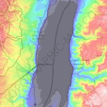
Name: Dead Sea topographic map, elevation, terrain.
Location: Dead Sea, Area C, Judea and Samaria, Palestinian Territory (31.31916 35.39093 31.76375 35.59138)
Average elevation: 101 m
Minimum elevation: -415 m
Maximum elevation: 1,061 m
Make a donation
Gear up for your next adventure:
As an Amazon Associate, this site earns from qualifying purchases at no extra cost to you.
Other topographic maps
Click on a map to view its topography, its elevation and its terrain.
An-Nabi Musa
Palestinian Territory > Judea and Samaria > Area C > Megilot Yam HaMelakh Regional Council > An-Nabi Musa
Average elevation: -156 m